The Confederation Bridge – Canada’s Engineering Marvel
- by Mohamed Adam

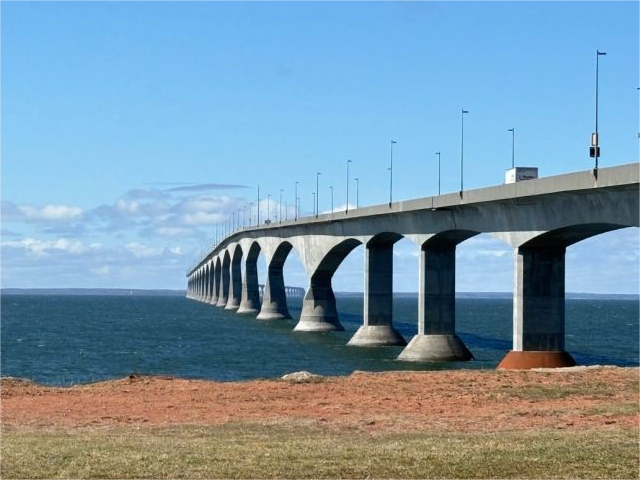
The Confederation Bridge stands as one of Canada’s most impressive feats of engineering, connecting the island province of Prince Edward Island (PEI) to mainland New Brunswick. Spanning the Northumberland Strait, this bridge is not just a critical transportation link but also a testament to modern engineering prowess.
The Confederation Bridge, often referred to simply as “The Bridge,” was officially opened to traffic on May 31, 1997. It was constructed to replace the ferry service that had long been the primary means of transportation between PEI and the rest of Canada. Named to commemorate the 1864 Charlottetown Conference, where the foundations for Canada’s Confederation were laid, the bridge serves as a symbol of the unity and progress of the Canadian federation.
The construction of the Confederation Bridge presented a myriad of engineering challenges, primarily due to the harsh environmental conditions of the Northumberland Strait. The region is known for its icy waters, strong currents, and high winds, all of which had to be meticulously accounted for in the bridge’s design and construction.
The bridge’s design is a cable-stayed structure, which was chosen for its ability to span long distances while minimizing the amount of material needed. This design feature was crucial given the significant ice forces that would be applied to the bridge’s piers.
To address these challenges, engineers employed advanced techniques and materials. The bridge is supported by 44 pylons, each encased in a massive concrete foundation that extends below the waterline. These foundations were constructed using a method known as “caisson” drilling, which involves sinking large concrete cylinders into the seabed to create a stable base. The caissons had to be designed to withstand the severe ice impact and the corrosive effects of saltwater.
The bridge is approximately 12.9 kilometers (8 miles) long, making it the longest bridge in the world over ice-covered waters. The structure includes a 7.3-kilometer (4.5-mile) section with a main span of 55 meters (180 feet), which allows for the passage of large ships. The design incorporates a slight curve, which not only adds to the aesthetic appeal but also helps to distribute the load more evenly.
The story behind the astounding Confederation Bridge is a long time coming and an interesting one. It all begins centuries ago with desire to get to and from the island.
Pre 1600’s – The Mi’kmaq
As a Mi’kmaq inhabitant, I live near Wuk’ta’mook (meaning “a crossing place”) where I can see the lands of Epekwitk (meaning “cradled on the waves” or “lying in the water”) across the plentiful waters. This is the closest point to the island (13 kilometres or 8 miles) known as the Abegweit Passage, so is my best route for canoeing across the wide waters, as my ancestors have done for many generations
Travelling across the strait becomes much more difficult in winter with ice along the shores and a combination of open water and ice floes in the middle of the strait. A combination of paddling, pushing, and pulling is required to navigate this route. I finally make it to Pastue’kati (meaning “a place where sea crows are plentiful”). I am safely on Epekwitk island (now known as Prince Edward Island).
1775 – Mail Service
As a mailman in February 1775, I have been tasked by Governor Walter Patterson to cross the Northumberland Strait by canoe. My trip begins from Wood Islands at the southern tip of Saint John’s Island (now Prince Edward Island).
The route takes me to Pictou Island then on to Pictou, Nova Scotia. In total, the distance is 37 kilometres (23 miles). It is a tough go navigating the ice floes and open water, but I do succeed. From what I hear, another attempt will be made next winter.
1827 – A Changed Route
After 50 years of sporadic winter mail delivery from Prince Edward Island (formally changed from St. John’s Island in 1799), myself, Neil Campbell, and my partner Donald McInnis set off to cross the Northumberland Straight by the shorter route popular with the Mi’kmaq.
We depart with our canoe from Cape Traverse (Pastue’kati in Mi’kmaq) and successfully traverse the ice and water. We’ are told our success will mean all the mail will travel this new route going forward.
1834 – Ice Boats
Enough with using canoes over the treacherous Northumberland Strait in the winter. New ice boats now make the journey. These boats are a least 16 feet in length and carry no more than four passengers. Each passenger’s baggage can weigh no more than 20 pounds.
The ice boats become more optimized as time goes on. Heavy tin covers the hull to protecting the wood from damage. Iron clad runners on either side of the keel, allow for the ice boat to move more easily over flat ice.
Oars and a small sail propel the ice boats across the open water. Leather straps with harnesses assist my men in pulling the boat over difficult ice. The harnesses also save the men if they fall through the ice, which does happen on occasion.
Unfortunately, mother nature sometimes adds challenges to our winter crossings. On occasion, bad weather and difficult ice conditions prevent the ice boat from making the journey in one day. This is very dangerous for the crew and passengers due to risk of frostbite and hypothermia.

1873 – Joining Canada
The Queen of England is petitioned by the Canadian Parliament for Prince Edward Island to be admitted into the Dominion of Canada. One of the conditions for this entry is for efficient steam service between P.E.I. and the mainland year round, allowing continuous communication with Canadian railway system. This becomes enshrined in the Canadian Constitution.
As is said often, easier said than done.
The Ships
Over the next 47 years, many attempts are made with newer and better steam ships to consistently travel across the Northumberland Strait through the winter. However, meeting the constitutional requirement of efficient steam service is elusive.
The first wooden-hauled steam ship tries to navigate the route between Georgetown and Pictou, but cannot withstand the Northumberland Strait ice.
A larger ship replaces the first, but also has its own challenges such as hull damage and occasionally getting stuck in the ice for days.
With pressure to achieve the promise of efficient steam service across the Strait, larger and larger ships are put into service over the years.
In 1917 the ferry route is changed to the shorter Borden to Cape Tormentine route. The ferry efficiency vastly increases with this new ferry route and a much more powerful ferry, capable of transporting 750 passengers along with 9 rail cars. Ice boats are no longer needed as backup for sporadic ferry service.
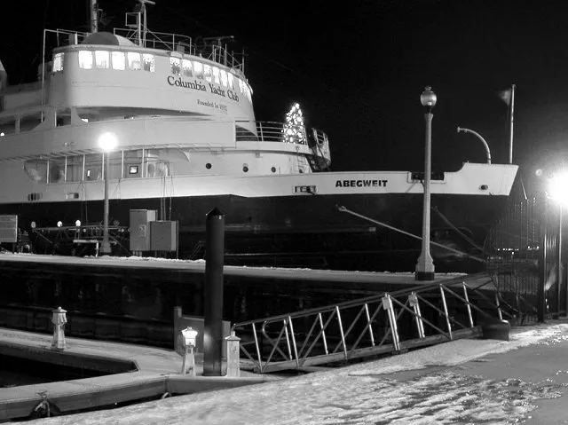
In 1947 the Abegweit ferry is added to the fleet. The Abegweit is twice as big as its predecessor and is the largest and most powerful icebreaker in the world for its day.
Retired in 1982, the Abegweit is now the clubhouse at Chicago’s Columbia Yacht Club on Lake Michigan.

A Fixed Link – Beginnings of the Confederation Bridge
The constant pressure of attaining efficient service to Prince Edward Island pushes government to consider some form of fixed link to the mainland.
1885 – The Tube Proposal
One of the first proposals, made in 1885, consists of 5 miles of iron tubes, each 300 feet long and 15 feet in diameter. This 5 mile tube will sit on a thick slab of concrete in order to support a railway track.
Long earthen wharves will be built out into the Strait at both ends to meet the iron tube. Shorter tunnels of similar design are already in use in London, England in 1885.
The consideration of a bridge is ruled out as the low level of the bridge envisioned would interfere with ship traffic. Also, bridge building techniques in this time period would result in winter ice tearing away any summer progress.
Proposing the tunnel concept to the British Colonial Minister in 1886, the British government refuses involvement. Further appeal directly to Prime Minister Sir John A MacDonald is also unsuccessful.
1928 – The Causeway Concept
In 1928, two fixed link options are under study. The first, the tube or tunnel, has a price tag of $40 million. A very hefty sum in the day.
In a new option, a causeway will be built across the Northumberland Strait, with various sections allowing for boats and ships to pass. The big concern is how the causeway will withstand the ice forces in winter storms.
Also, the cost estimate of $46 million makes it even pricier than the tunnel option. Neither option gets support to move forward.
1962 – Another Causeway Proposal
In the early 1950’s, the island of Cape Breton is connects to mainland Nova Scotia with a 1.6 kilometres (1 mile) causeway and short bridge. This sparks renewed interest in connecting P.E.I. to the mainland of Canada.
In 1962, the Canadian Government agrees to pursue the design and construction of a fixed link. The winning design is a combination bridge, causeway, and tunnel. In 1965, the first awarding of contracts happens. Groundbreaking on P.E.I. for the highway approach commences.
In 1967, bids on the New Brunswick side are significantly higher. Reassessing cost estimates and considering alternative approaches drags on. This suspends further work at the time.
In 1968, a new federal government forms with Pierre Elliott Trudeau at the helm. Early 1969 brings the cancellation of the fixed link project.
The Confederation Bridge stands as one of Canada’s most impressive feats of engineering, connecting the island province of Prince Edward Island (PEI) to mainland New Brunswick. Spanning the Northumberland Strait, this bridge is not just a critical transportation link but also a testament to modern engineering prowess. The Confederation Bridge, often referred to simply as…


